


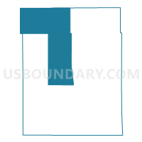
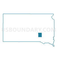
VTD-precinct 4, Aurora County, South Dakota
About
Outline

Summary
| Unique Area Identifier | 666993 |
| Name | VTD-precinct 4 |
| County | Aurora County |
| State | South Dakota |
| Area (square miles) | 139.35 |
| Land Area (square miles) | 139.01 |
| Water Area (square miles) | 0.35 |
| % of Land Area | 99.75 |
| % of Water Area | 0.25 |
| Latitude of the Internal Point | 43.82434400 |
| Longtitude of the Internal Point | -98.65390040 |
Maps

Graphs
Select a template below for downloading or customizing gragh for VTD-precinct 4, Aurora County, South Dakota


Neighbors
Neighoring Voting District (by Name) Neighboring Voting District on the Map
- VTD precinct 2, Brule County, SD
- VTD-precinct 2, Aurora County, SD
- VTD-precinct 2, Jerauld County, SD
- VTD-precinct 3, Aurora County, SD
- VTD-precinct 5, Jerauld County, SD
- VTD-precinct 5, Aurora County, SD
- VTD-precinct 6, Aurora County, SD
Top 10 Neighboring County Subdivision (by Population) Neighboring County Subdivision on the Map
- Plankinton township, Aurora County, SD (211)
- White Lake township, Aurora County, SD (87)
- Pleasant Lake township, Aurora County, SD (74)
- Gales township, Aurora County, SD (54)
- Crow Lake township, Jerauld County, SD (54)
- Crystal Lake township, Aurora County, SD (51)
- Lake township, Aurora County, SD (49)
- Willow Lake township, Brule County, SD (42)
- Eureka township, Aurora County, SD (38)
- Viola township, Jerauld County, SD (38)
Top 10 Neighboring Unified School District (by Population) Neighboring Unified School District on the Map
- Wessington Springs School District 36-2, SD (1,884)
- Kimball School District 07-2, SD (1,461)
- Plankinton School District 01-1, SD (1,281)
- White Lake School District 01-3, SD (723)
Top 10 Neighboring State Legislative District Lower Chamber (by Population) Neighboring State Legislative District Lower Chamber on the Map
- State House District 20, SD (22,214)
- State House District 22, SD (21,252)
- State House District 21, SD (21,057)
Top 10 Neighboring State Legislative District Upper Chamber (by Population) Neighboring State Legislative District Upper Chamber on the Map
- State Senate District 20, SD (22,214)
- State Senate District 22, SD (21,252)
- State Senate District 21, SD (21,057)
Top 10 Neighboring 111th Congressional District (by Population) Neighboring 111th Congressional District on the Map
Top 10 Neighboring Census Tract (by Population) Neighboring Census Tract on the Map
- Census Tract 9736, Aurora County, SD (2,710)
- Census Tract 9731, Brule County, SD (2,657)
- Census Tract 9741, Jerauld County, SD (2,071)